
MANILA, Philippines --- Tropical Cyclone Wind Signals (TCWS) are still raised in parts of Luzon on Wednesday due to tropical storm Pepito, as the Philippine Atmospheric, Geophysical and Astronomical Services Administration (Pagasa) monitors a new tropical depression outside the Philippine area of responsibility.
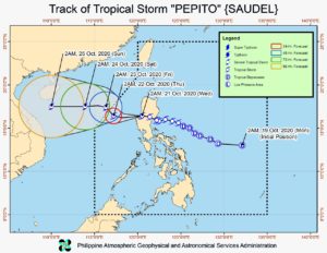
The center of Pepito was last spotted 40 kilometers north-northwest of Dagupan City, Pangasinan. It is packing maximum sustained winds of 75 kilometers per hour near the center and gustiness of up to 115 kph, and is moving west northwestward at 30 kph, according to the severe weather bulletin issued by Pagasa at 5 a.m.
Meanwhile, the tropical depression outside PAR was last spotted 1,880 km east-northeast of extreme northern Luzon. It has maximum sustained winds of 55 kph near the center and gustiness of up to 70 kph. Pagasa said the tropical depression is currently almost stationary and is unlikely to enter PAR.
According to Pagasa, "Pepito" is forecast to gradually intensify over the West Philippine Sea and may reach the severe tropical storm category by Thursday afternoon or evening.
"'Pepito' is forecast to move generally westward over the West Philippine Sea today, before slowing down and turning northwestward tomorrow. It is forecast to exit the Philippine Area of Responsibility tomorrow morning or afternoon," it added.
On the forecast track, "Pepito" will accelerate and turn westward beginning Friday towards the central portion of Vietnam.
For the weather forecast, Pagasa said "Pepito" will bring moderate to heavy rains over Batanes, Cagayan, Ilocos Norte, Pangasinan, La Union, Apayao, Benguet, Zambales, Bataan, Occidental Mindoro, and Calamian Islands.
Meanwhile, light to moderate with at times heavy rains will be experienced over Metro Manila and the rest of Luzon. Pagasa warned that flooding and rain-induced landslides may occur during heavy or prolonged rainfall especially in areas that are highly or very highly susceptible to these hazards.
TCWS No. 2 is raised in the following areas, where winds of 61 kph up to 120 kph may be expected in at least 24 hours:
- Ilocos Sur
- La Union
- Pangasinan
- Benguet
- Tarlac
- northern portion of Zambales (Iba, Palauig, Masinloc, Candelaria, Santa Cruz, Botolan, Cabangan)
TCWS No. 1 is raised in the following areas, where winds of 30 to 60 kph may be expected in at least 36 hours or intermittent rains may be expected within 36 hours:
- Ilocos Norte
- Kalinga
- Abra
- Ifugao
- Mountain Province
- southern portion of Isabela (Palanan, San Mariano, Benito Soliven, Naguilian, Gamu, Burgos, San Manuel, Aurora, Cabatuan, Luna, Reina Mercedes, Cauayan City, Dinapigue, San Guillermo, Angadanan, Alicia, San Mateo, Ramon, San Isidro, Echague, San Agustin, Jones, Santiago City, Cordon)
- Quirino
- Nueva Vizcaya
- Aurora
- Nueva Ecija
- Bulacan
- Pampanga
- rest of Zambales
- Bataan
According to Pagasa, gale-force winds and high (strong to near gale) winds will be experienced in areas under TCWS No. 2 and 1, respectively. High to gale-force winds due to the northeasterly surface wind flow will also be experienced over the rest of northern Luzon, especially in coastal and mountainous areas.
The weather bureau added that rough to very rough seas (2.5 to 5.5 m) will be experienced over the areas where TCWS and gale warning are in effect, particularly over the entire seaboards of Northern and Central Luzon, the seaboard of northern Quezon including Polillo Islands, and the western seaboards of Batangas, Occidental Mindoro (including Lubang Islands), and Palawan (including Calamian and Kalayaan Islands). Sea travel is risky over these areas, especially for those using small seacraft.
Meanwhile, moderate to rough seas (1.5 to 3.0 m) will prevail over the eastern seaboards of southern Quezon, Bicol Region, Eastern Visayas, Caraga, and Davao Region.
"Those with small seacrafts are advised to take precautionary measures when venturing out to sea. Inexperienced mariners should avoid navigating in these conditions," Pagasa said.
EDV